
Welcome to Alaska and the first stage of our World Sightseeing Tour, a series of bush trips that will take you on a grand tour to see all this world has to offer. In the first leg of the journey you’ll be exploring the tundra of the Seward Peninsula before heading across to the Brooks Mountain Range, cutting through the valleys of the Gates of the Arctic National Park. You’ll then explore some of the mighty Yukon river before making your way south to the city of Fairbanks.
Total Legs: 15 Total Distance: 949 Total Time(125kts): 7 hours 35 minutes
Leg 1
Flying from PAIW
Leg Distance: 63.34 Approximate time at 125kts: 30 minutes.
Wales(PAIW) to Lopp Lagoon(POI1)
Distance: 4.93NM Bearing: 5° 2 minutes
Head north until you meet the coastline a few miles north of the airport, then follow it as it curves around to the northeast
Lopp Lagoon(POI1) to Ikpek Lagoon(POI2)
Distance: 19.32NM Bearing: 54° 9 minutes
Keep following the coast and it's companion lagoons northeast
Ikpek Lagoon(POI2) to Shishmaref Inlet(POI3)
Distance: 32.04NM Bearing: 48° 15 minutes
After following the coast and the long, thin Arctic Lagoon, you'll soon come to a large inlet which is shielded by a small island. The airfield is on this island
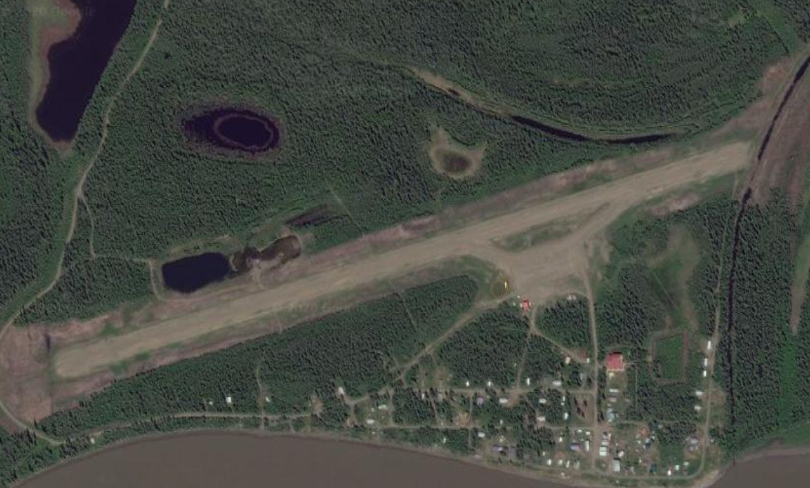
Shishmaref Inlet(POI3) to Shishmaref(PASH)
Distance: 7.05NM Bearing: 40° 3 minutes
The airfield sits in the middle section of the island and should be easy to spot

Leg 2
Flying from PASH
Leg Distance: 82.59 Approximate time at 125kts: 40 minutes.
Shishmaref(PASH) to Shishmaref Inlet(POI4)
Distance: 14.22NM Bearing: 107° 7 minutes
Head southeast after takeoff and make your way to the other end of the inlet that leads to a river mouth. From there we'll head east
Shishmaref Inlet(POI4) to Kotzebue Sound(POI5)
Distance: 40.93NM Bearing: 83° 20 minutes
Heading directly east over the land, you'll eventually arrive at the western shore of Kotzebue Sound
Kotzebue Sound(POI5) to Kotzebue Sound(POI6)
Distance: 15.07NM Bearing: 97° 7 minutes
Follow the edge of the bay eastwards along the shore
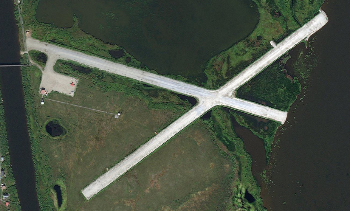
Kotzebue Sound(POI6) to Deering(PADE)
Distance: 12.37NM Bearing: 81° 6 minutes
At the far end of a double promontory sticking out into the bay lies the X-shaped Deering Airport

Leg 3
Flying from PADE
Leg Distance: 39.82 Approximate time at 125kts: 19 minutes.
Deering(PADE) to Kiwalik(POI7)
Distance: 22.34NM Bearing: 88° 11 minutes
After takeoff, keep following the shoreline east until you arrive at a lagoon where the coast turns sharply north. The slice of land that sticks out into the lagoon points directly to your next destination
Kiwalik(POI7) to Buckland(PABL)
Distance: 17.48NM Bearing: 88° 8 minutes
After passing over a couple of low lying hills, you should see the town of Buckland and its airport a few miles ahead

Leg 4
Flying from PABL
Leg Distance: 53.02 Approximate time at 125kts: 25 minutes.
Buckland(PABL) to Buckland River(POI8)
Distance: 14.25NM Bearing: 0° 7 minutes
Head north from the airport, following the river as it winds its way to Eschsholtz Bay
Buckland River(POI8) to Selawik Lake(POI9)
Distance: 13.02NM Bearing: 35° 6 minutes
Turn and head northeast to fly overland to Selawik Lake
Selawik Lake(POI9) to Selawik Lake(POI10)
Distance: 10.01NM Bearing: 75° 5 minutes
When you reach the lake, turn to the east and follow the shore until it curves around to the north
Selawik Lake(POI10) to Inland Lake(POI11)
Distance: 12.33NM Bearing: 27° 6 minutes
Turn northeast again and you'll be heading across a group of large lakes. Head to the northern side of the largest lake
Inland Lake(POI11) to Selawik(PASK)
Distance: 3.41NM Bearing: 331° 2 minutes
Turning north towards a smaller lake, you should see the airport on its western edge
Leg 5
Flying from PASK
Leg Distance: 74.93 Approximate time at 125kts: 36 minutes.
Selawik(PASK) to Selawik River(POI12)
Distance: 23.59NM Bearing: 79° 11 minutes
Head directly east from the airport and you'll soon be alongside the Selawik River as it manically winds its way east
Selawik River(POI12) to Kugarak River(POI13)
Distance: 10.61NM Bearing: 29° 5 minutes
You'll soon come across a smaller river heading off to the northeast. Turn left and follow it
Kugarak River(POI13) to Kugarak River(POI14)
Distance: 11.47NM Bearing: 86° 6 minutes
Keep following the river as it turns to the east and heads towards a small mountain range
Kugarak River(POI14) to Sheklukshuk Range(POI15)
Distance: 14.84NM Bearing: 75° 7 minutes
Leave the river and follow the mountain range along its southern edge
Sheklukshuk Range(POI15) to Kobuk River(POI16)
Distance: 10.25NM Bearing: 29° 5 minutes
After passing the mountains, turn to the northeast for about 10nm and you come to another winding river called the Kobuk river
Kobuk River(POI16) to Shungnak(PAGH)
Distance: 4.17NM Bearing: 58° 2 minutes
Turning to the east you should see Shungnak Airport on the north side of the river

Leg 6
Flying from PAGH
Leg Distance: 55.4 Approximate time at 125kts: 27 minutes.
Shungnak(PAGH) to Pick River(POI17)
Distance: 9.37NM Bearing: 138° 4 minutes
Fly southeast from the airport, following the small river as it heads towards some mountains
Pick River(POI17) to Lockwood Hills(POI18)
Distance: 18.33NM Bearing: 123° 9 minutes
Keep flying southwest to the right side of the hills. You'll also see another hilly range ahead that we'll follow on their left side
Lockwood Hills(POI18) to Zane Hills(POI19)
Distance: 21.36NM Bearing: 126° 10 minutes
Keep heading southeast, this time keeping the next mountain range to your right. The next airport sits in the foothills of its eastern edge
Zane Hills(POI19) to Hog River(2AK6)
Distance: 6.34NM Bearing: 139° 3 minutes
As the edge of the mountain range turns to the south, follow it and you should see the clearing of Hog River airstrip a few miles ahead

Leg 7
Flying from 2AK6
Leg Distance: 51.9 Approximate time at 125kts: 25 minutes.
Hog River(2AK6) to Lake Tokhaklanten(POI20)
Distance: 23.81NM Bearing: 76° 11 minutes
Head east (and slightly north) after takeoff over some low hills and you'll come to a medium sized lake
Lake Tokhaklanten(POI20) to Indian Mountains(POI21)
Distance: 23.78NM Bearing: 108° 11 minutes
At the lake, turn to the southeast and you'll see a small mountain range ahead. Head for the highest peak at the southern end of this range
Indian Mountains(POI21) to Indian Mountain LRRS(PAIM)
Distance: 4.31NM Bearing: 70° 2 minutes
Pass just to the left of the peak, then the airport will be lined up 4 miles ahead just to your left

Leg 8
Flying from PAIM
Leg Distance: 85.95 Approximate time at 125kts: 41 minutes.
Indian Mountain LRRS(PAIM) to Indian River(POI22)
Distance: 5.96NM Bearing: 59° 3 minutes
After takeoff, follow the river to the east where it will turn north easterly and follow a group of hills
Indian River(POI22) to Notoniono Creek(POI23)
Distance: 8.03NM Bearing: 21° 4 minutes
Keep following the river as it passes the northern end of the hills and turns north east
Notoniono Creek(POI23) to Mentanontli River(POI24)
Distance: 5.9NM Bearing: 37° 3 minutes
Keep following the creek as it heads northwest and meets up with the Mentanontli River
Mentanontli River(POI24) to Koyukuk River(POI25)
Distance: 16.84NM Bearing: 359° 8 minutes
This river will continue winding northeast through a shallow valley and eventually meet up with the Kanuti River which flows for a short while north before hitting the even larger Koyukuk River
Koyukuk River(POI25) to Allakaket(POI26)
Distance: 9.49NM Bearing: 43° 5 minutes
Follow the river northeast to the town of Allakaket
Allakaket(POI26) to Koyukuk River(POI27)
Distance: 14.02NM Bearing: 78° 7 minutes
Continue following the river east
Koyukuk River(POI27) to Koyukuk River(POI28)
Distance: 9.78NM Bearing: 35° 5 minutes
Continue along the river as it turns to the north
Koyukuk River(POI28) to Bettles(PABT)
Distance: 15.93NM Bearing: 3° 8 minutes
Follow the river northward until you see the airport off to the right, sitting at the edge of one of the river's many turns

Leg 9
Flying from PABT
Leg Distance: 30.31 Approximate time at 125kts: 15 minutes.
Bettles(PABT) to John River(POI29)
Distance: 15.84NM Bearing: 312° 8 minutes
Head northwest from Bettles and you'll soon be following the John River at it makes its way north into the mountains
John River(POI29) to Crevice Creek(1AK1)
Distance: 14.47NM Bearing: 337° 7 minutes
Keep following the river through the valley and you will come to Crevice Creek landing strip, which sits at the junction of the John River and three other smaller rivers

Leg 10
Flying from 1AK1
Leg Distance: 53.25 Approximate time at 125kts: 26 minutes.
Crevice Creek(1AK1) to John River(POI30)
Distance: 13.8NM Bearing: 327° 7 minutes
The north end of the runway points to the path ahead, as the John River continues the journey north through the mountains
John River(POI30) to John River(POI31)
Distance: 10.89NM Bearing: 320° 5 minutes
At the junction of the valleys, continue following the main river to the north (and slightly northwest)
John River(POI31) to John River(POI32)
Distance: 17.93NM Bearing: 10° 9 minutes
Keep following the river as it turns slightly to the north east. At the next junction where the valley opens out, take the right fork and continue to the north east
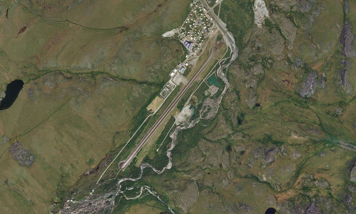
John River(POI32) to Anaktuvuk Pass(PAKP)
Distance: 10.63NM Bearing: 37° 5 minutes
As the valley opens out once again, stay to the right and head northeast. You will see the airport up ahead in the center of the valley
Leg 11
Flying from PAKP
Leg Distance: 57.97 Approximate time at 125kts: 28 minutes.
Anaktuvuk Pass(PAKP) to Gates of the Arctic(POI33)
Distance: 14.08NM Bearing: 15° 7 minutes
Heading northeast, now following the Anaktuvuk River, we'll soon emerge from the mountains and turn to the east
Gates of the Arctic(POI33) to Shainin Lake(POI34)
Distance: 8.14NM Bearing: 72° 4 minutes
Head east along the northern edges of the mountains, you will come across a small lake
Shainin Lake(POI34) to Itkillik Lake(POI35)
Distance: 24.78NM Bearing: 63° 12 minutes
Continue following the northern edge of the mountains as you head east/northeast. You should next cross paths with Itkillik Lake which sits in a small river valley. Continue east
Itkillik Lake(POI35) to Galbraith Lake(PAGB)
Distance: 10.97NM Bearing: 63° 5 minutes
After you pass the next set of hills, Galbraith Lake should be straight ahead, with the airstrip at its north end
Leg 12
Flying from PAGB
Leg Distance: 79.99 Approximate time at 125kts: 38 minutes.
Galbraith Lake(PAGB) to AK-11(POI36)
Distance: 8.5NM Bearing: 142° 4 minutes
Follow the Atigun river and state highway 11 south into the valley
AK-11(POI36) to Atigun Pass(POI37)
Distance: 13.21NM Bearing: 176° 6 minutes
Keep following the highway south where it will eventually climb to Atigun Pass
Atigun Pass(POI37) to Atigun Pass(POI38)
Distance: 2.27NM Bearing: 228° 1 minutes
Follow the road through the pass and south into the next valley. Beware of the quick elevation change
Atigun Pass(POI38) to Chandalar Shelf(POI39)
Distance: 4.04NM Bearing: 186° 2 minutes
The road will head south through a narrow valley. A wider valley will shortly open out to the east. This is where we will leave the road and turn left down the wide valley, following the south fork of the Chandalar River
Chandalar Shelf(POI39) to Chandalar River(POI40)
Distance: 19.22NM Bearing: 118° 9 minutes
Keep following the river southeast as it meets up with its north fork
Chandalar River(POI40) to Chandalar River(POI41)
Distance: 8.97NM Bearing: 79° 4 minutes
Stay with the river as it turns east
Chandalar River(POI41) to Chandalar River(POI42)
Distance: 8.13NM Bearing: 111° 4 minutes
The river will continue south east
Chandalar River(POI42) to Chandalar River(POI43)
Distance: 10.85NM Bearing: 189° 5 minutes
The river will turn to the south and make its way to Chandalar Lake
Chandalar River(POI43) to Chandalar Lake(PALR)
Distance: 4.8NM Bearing: 169° 2 minutes
Heading south along the lake, you should see the airport straight ahead on its left bank
Leg 13
Flying from PALR
Leg Distance: 85.57 Approximate time at 125kts: 41 minutes.
Chandalar Lake(PALR) to Chandalar River(POI44)
Distance: 13.73NM Bearing: 204° 7 minutes
Leaving the airport southwest along the lake and then turning south, follow the river as it takes us out of the mountains
Chandalar River(POI44) to Yukon Flats(POI45)
Distance: 16.84NM Bearing: 145° 8 minutes
As the river starts to turn to the southeast, it will point you in the direction of a hilly range. Head southeast over the hills towards the taller peak in the distance
Yukon Flats(POI45) to Pitka Fork(POI46)
Distance: 22.48NM Bearing: 158° 11 minutes
Directly south of here you'll see a small river passing between some low lying hills in the distance. Follow this river as it heads southeast
Pitka Fork(POI46) to Hodzana River(POI47)
Distance: 22.11NM Bearing: 113° 11 minutes
The small river will meet up with the larger Hodzana River and wind its way southeast
Hodzana River(POI47) to Beaver(PAWB)
Distance: 10.41NM Bearing: 109° 5 minutes
Just as the river makes its final turn south to meet the mighty Yukon river, continue southeast and Beaver airport will be ahead, on the northern bank of the Yukon
Leg 14
Flying from PAWB
Leg Distance: 45.08 Approximate time at 125kts: 22 minutes.
Beaver(PAWB) to Yukon River(POI48)
Distance: 21.4NM Bearing: 232° 10 minutes
Follow the Yukon river as it winds its way to the southwest
Yukon River(POI48) to Stevens Village(SVS)
Distance: 23.68NM Bearing: 224° 11 minutes
Just before the Yukon river starts nearing some low hills, you will see Stevens Village airport sitting in the middle of one of the river's U-turns

Leg 15
Flying from SVS
Leg Distance: 89.73 Approximate time at 125kts: 43 minutes.
Stevens Village(SVS) to AK-11(POI49)
Distance: 26.32NM Bearing: 161° 13 minutes
Heading southeast from Stevens Village, we'll cross some hills and soon meet up with Alaska Highway 11. Follow it as it heads east
AK-11(POI49) to AK-2(POI50)
Distance: 19.72NM Bearing: 100° 9 minutes
The highway will meet with AK-2 and continue east, where it will cross the Tolovana River before turning to the southeast
AK-2(POI50) to AK-2(POI51)
Distance: 32.37NM Bearing: 135° 16 minutes
Continue southeast with the highway as it meanders across the hills
AK-2(POI51) to Fairbanks Intl(PAFA)
Distance: 11.32NM Bearing: 197° 5 minutes
As the highway heads through the hills north of the city, you'll see Fairbanks Intl Airport off to the right, sitting on the western edge of town
